
Virtually every visitor to Hong Kong crosses the Tsing Ma Bridge – it is the only route linking Hong Kong International Airport to the rest of the city. But what most people don’t know is that the bridge has a second roadway for emergency use, located beneath the main deck.
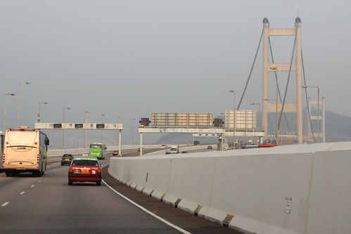
The second longest suspension bridge at time of completion in 1997, the Tsing Ma Bridge has a main span of 1,377 metres (4,518 ft) and a clearance below of 62 metres (203 ft), the towers being 206 metres (676 ft) high. Together with the Ma Wan Viaduct and the Kap Shui Mun Bridge, it forms the 3.5 kilometre long Lantau Link, with six road lanes on the top deck, and two railway tracks and two road lanes on the lower deck.

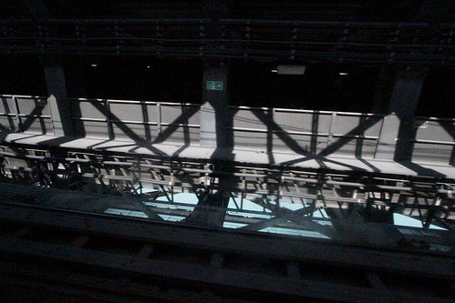
The railway tracks carry trains on the MTR Airport Express and Tung Chung lines between Lantau Island and the rest of Hong Kong, but there isn’t much to see from the train window – just steel bridge trusses, and blue water far below the tracks.
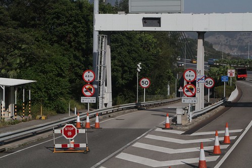
The lower deck also houses two single lane roadways for emergency use. The entry at the Lantau Island end of the bridge is easy to see.
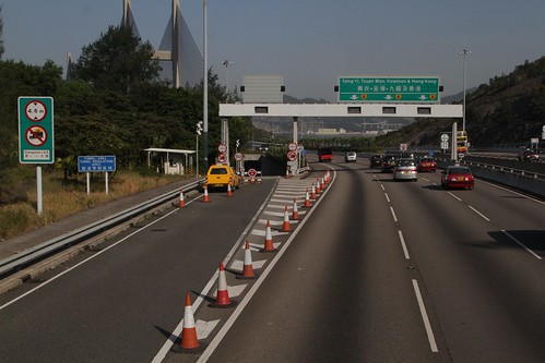
The roadway has 50 km/h speed limit, with vehicles over 4.6 metres high or carrying dangerous goods being banned from the confined space.
The lower roadway is only open when required – with special regulations applied during periods of high winds.
Stage I
Hourly mean wind speed in excess of 40 kph but not exceeding 65 kph
- Wind susceptible vehicles will be banned from using the Upper Deck of the Lantau Link and be diverted to use the Lower Deck.
- Centre lanes (both directions) of Lantau Link will be closed to road traffic by displaying a “red cross” lane use signal.
- Changing lanes on the Upper Deck is not allowed when the centre lane is closed.
- All vehicles must observe the speed limit of 50 kph.
Stage II
Hourly mean wind speed in excess of 65 kph
- Upper Deck of the Lantau Link will be completely closed.
- All vehicles should use the Lower Deck of the Lantau Link.
Here we see a motorcyclist headed west through the lower deck roadway after typhoon signal 8 was raised.
The same view from onboard a double decker bus.
As well as the journey back east over the bridge.
Footnote
Until 2015 the Tsing Ma Bridge Marathon also resulted in traffic being diverted onto the lower roadway with runners taking over the top deck – the route has since changed to avoid traffic disruptions.
Further reading
Photos of the Tsing Ma Bridge under construction, including views of inside the lower deck.

Fascinating article!
I’ve always wondered why I could never see outside properly when riding along the Tung Chung line. it’s a question that I couldn’t answer since I moved from HK to Australia.
I wonder why the road configuration on the lower deck is like that though. It would make more sense to move the train lines to the outside for better views and for the maximum bending moment in the horizontal sections in the cross section of the bridge deck to be reduced.
It isn’t common for suspension bridges to carry a railway – as the Tsing Ma Bridge showes it isn’t impossible, but the engineering is more difficult:
http://engineering.stackexchange.com/questions/435/what-makes-suspension-bridges-unsuitable-for-railways
I’m going out on a limb and assuming that placing the two tracks side by side in the centre was the easiest way to make the design work.
Putting the two roadways on the outside gives the added benefit of separating conflicting traffic flows, enhancing safety, but also means vehicles can’t easily drive around any accidents that do occur.
This paper titled ‘Design evolution of the Tsing Ma bridge’ has more detail on how the lower deck railway was engineered:
http://www.e-periodica.ch/cntmng?pid=bse-re-003:1991:64::104
The initial 1982 plans had the roadway in the middle, and railway at the sides. This was revised in 1990.
Speaking of the Tung Chung, do you know anything about the empty viaduct that is located between Lai King and Tsing Yi station?
Short answer from https://hkrailway.org/chi/mtrtrip.html
I’ve got a longer blog post on this subject in the works. 😀
Pingback: Giovanni Saccà a Bari: Il collegamento stabile dello Stretto di Messina – EXPERIENCES